Trinity Hills Park Community Meeting Notes (5/30/24)
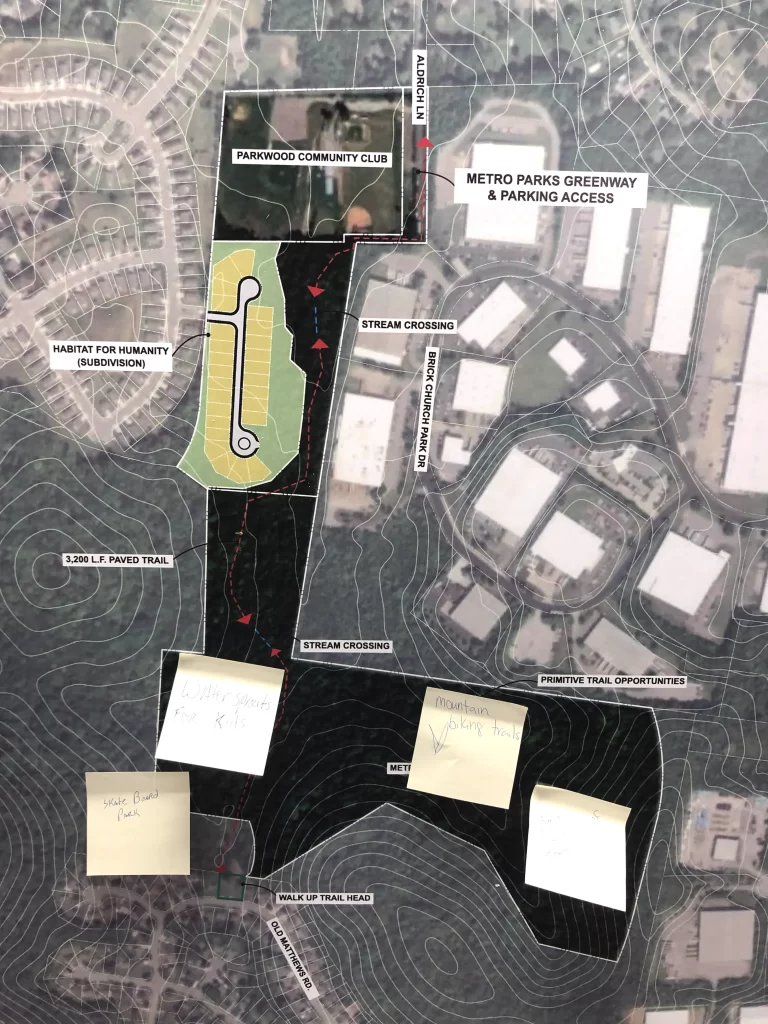
I attended the Trinity Hills Park Community Meeting this evening, which opened preliminary community feedback for the area and options within the park. The park will be approximately 56 acres and in an “L” shape. The park’s northern edge will extend next to the Parkwood Community Club and access Aldrich Ln, where there will be parking and other general amenities, including possible playgrounds and adult exercise areas. A proposed greenway roughly 6/10ths of a mile will run North and South, between a new Habitat for Humanity development and the adjacent industrial park. The Greenway is expected to connect to Old Matthews Rd via an existing metro easement.
The largest unknown for the park is what will occupy the largest section of acreage in the southeastern portion of land. The land is rugged, and limited options are available. This area is suited well for primitive hiking, or as myself and others suggested — a new mountain bike trail! I hope other members of the cycling and mountain bike community will continue to be vocal about the possibility of this.
Questions from community members ranged from the potential park name to amenities, signage, security, and if there were any beautification agreements between Habitat for Humanity and the Parkwood Community Club. Metro Parks representatives noted that agreements with both groups had been made regarding updating certain aspects, including neighborhood access to the greenway from the Habitat for Humanity development. Metro Parks officials also said the park’s opening timeline would likely be late summer, or early fall 2025. As more information and meetings come together, I will do my best to share all of it!
Ravenwood Park Phase 2
In other conversations with parks department officials, I learned that Phase 2 of the Ravenwood Park expansion is far from what the master plan had indicated. The Parks Department recently submitted their final comments to the engineering firm, and are waiting for final adjustments. They are currently scoping out the process and costs of removing existing structures (ie. old semi-trailers, tractors, etc.) from the land.
For the park itself, there will be a primitive walking path (not a greenway) that runs along the perimeter of the river and cuts across the grasslands from one side to the other near the southern end. There will be a few observation/lookout areas along the pathway. My understanding was that entrances to the pathway will be on the existing greenway near the pedestrian bridge to Hartman Park, and at the existing gate along the greenway. They seemed to indicate that bicycles would not be allowed on the new pathway, and the existing greenway would not be rerouted in any manner. Get your gravel laps in while you can!
Greenways Maps & Watkins Pump Track
Greenways for Nashville were also present and shared their new Nashville’s Greenways Map for Spring 2024. They had print copies available, but the PDF version has not been shared yet. Look out for that shortly.
In other parks/cycling news — the Watkins Park Pump Track has been approved for an expansion. The first community meeting regarding this is upcoming Wednesday, June 5th. If you’re interested and want to be involved, check out the Wheel Park Community Engagement meeting to learn more.